Thursday, 16 May 2013

Ascending Ascension

[This is a diary of a life in the Falkland Islands, in the south Atlantic.  Last month, we headed north to re-visit the UK (of which, see next blog), and stopped en route on Ascension Island for some heat and history (naval and natural).  Flights to and from the UK (and the Falklands) refuel here.  It may not look far on a map, but the Falklands are further from London than Hawaii or Bali!]

We began our journey with an escort................
A close encounter of the Falkland's kind.....(courtesy of the RAF).
Ascension Day is celebrated around 40 days after Easter.  In 1503, on Ascension Day, Portuguese sailors sighted a bare, volcanic island in the middle of the Atlantic, just south of the Equator.  They found fresh food in the shape of Green Turtles laying eggs on the beaches.

Five hundred years on, Ascension Island is still barren and in the middle of the Atlantic, and Green Turtles still lay their eggs on the beaches, but some things have changed since 1503...

For more detail on the island, try here >> http://en.wikipedia.org/wiki/Ascension_Island
Falklands to Ascension I. - about 8 hours' flying.
Ascension Island is a remnant of the British Empire - where the Royal Navy ships could re-supply with food and water while commanding the seas between the UK and Africa and South America.  It's also the remnant of a huge volcanic upwelling from the mid-Atlantic Ridge, about 1 million years ago.  The island of Jersey, in the English Channel, is slightly bigger, and has more people - 90,000 compared to less than 900 on Ascension.
London - 4,830 miles..
It's a long way from anywhere, but handily for Falkland Islanders, its position about halfway between themselves and London enabled the island to be used as a refuelling stop by ships and aircraft heading to rescue the Islanders from Argentinian invaders in 1982.   However, there is a strong American presence on the island, and the then US Secretary of State, Alexander Haig, reportedly offered to allow the British Task Force to land on Ascension, before being brusquely told that Britain did not require US permission when using one of her own islands!
Ascension Is. - volcanoes and satellite dishes...
The island's strategic, if lonely, location has meant it has been vital in providing a link between the continents, and latterly, tracking satellites.  The telegraph cable between London and Cape Town came through here, and many others followed.  It was virtually a private fiefdom of Cable & Wireless, the communications company, for many years, before becoming a UK Overseas Territory.

The Americans are there because during the Second World War, they built an air base (called "Wideawake" - the name for the terns who breed here in their thousands) which allowed planes to fly safely across the Atlantic to the North African and European theatres of war.
Ascension Is airport transit lounge.
After the war, the base was abandoned to the turtles, terns and telecomms people, but when the Space Race escalated in the '50s and '60s, Ascension Island provided a vital link in the chain of tracking stations which monitored Russian and American spacecraft.
Government House, Georgetown.
I believe the CIA (and GCHQ) also monitored the airwaves there, but now the BBC and the Ariane Space Project continue to have  installations.  There is still a US Air Force base, as well as an RAF presence.  Add in civilian workers (mostly from St Helena), and the population totals about 800.  There is no indigenous population, and no-one can live there unless they have a job.
Lunch arrives.....
It's a very relaxed outpost, and within minutes of arriving, we had wandered a few hundred yards through the tiny capital, Georgetown, from the only hotel to the pier and watched fishermen bring ashore the day's catch!
You can't get any fresher than this!  30 minutes from sea to table.
A 200-pound tuna was just being dragged up the steps to a steel table, where the fish was quickly converted into tuna steaks.  I had a couple of these during our stay and they were the biggest and tastiest tuna steaks I've eaten, not to mention the freshest!
Freshly-caught Wahoo or....... Barracuda.
While we were watching the fish being worked on, we gazed along the idyllic-looking sandy beach with the Atlantic swell breaking gently on it.  We also noticed many black fish in the crystal-clear waters below.  We entertained thoughts of going for a cooling swim or snorkel, until we watched the remains of the tuna being heaved into the sea.
Trigger fish disposing of the leftovers.
There was an immediate feeding frenzy on the carcass as hundreds of fish converged on the remains.  All thoughts of going for a paddle in the sea were dismissed!

However, there are a few activities on the island, other than feeding the fish, to keep one entertained.  Apart from playing the "worst golf course in the world" - the greens are made of brown volcanic rock - there are many interesting walks.  Some fellow Falkland Nordic Walkers had visited the island last year and told me about the great walking on Green Mountain........
Ascending Green Mountain
Green Mountain is just under 3,000 feet (900m) high, and there is a very twisty road most of the way up.  The road takes you from sea-level, and the arid interior of the island, through scrub, to a verdant forest surrounding the summit.
30 hairpin bends on the mountain road!
When Napoleon was exiled to St Helena (800 miles to the south-east) in 1815, Royal Marines were stationed on Ascension Island to keep lookout for French frigates on a rescue mission.  Green Mountain gave the best vantage point, and the Marines created many paths around the summit.   A great feature of these paths, is that they are on the same level around the hill, with many tunnels cut into the solid rock to avoid walking beside a sheer cliff-face.
Green Mountain
One of the drawbacks of the island is the lack of water, and many attempts have been made to find springs or collect the rainwater.  Nowadays, a desalination plant provides sufficient water, but for centuries the arid island made life difficult for sailors.

Not a common sight in the Falklands, but a roadside plant here!
However, after a visit in 1843, Joseph Hooker suggested that Kew Gardens send as many plants as possible to encourage greenery and, hopefully, rainfall.  And so, the mountainside is festooned with an eclectic mix of trees and shrubs from around the globe - pines, eucalyptus, bamboo and bananas all thrive there.  And the plan worked - a cloud forest now envelopes Green Mountain!
Light at the end of the tunnel
We  followed a trail which was almost level at about 2,500 feet.  A brisk hour-long walk would give a 360 degree vista of the island and surrounding ocean, so the Marines' efforts seemed worthwhile, and Napoleon was never rescued!
Narrow cutting
The foliage was constantly changing, too, with rock walls covered with maidenhair ferns, and huge ginger plants in bloom.
Ascension lily
What also made the walks interesting was a number of letterboxes.  These may have begun from the tradition of leaving letters on islands for other passing ships to take back to their destination.  But, more likely, from the letterboxes on Dartmoor, Cornwall, which provide entertainment for walkers there.
One of the many letterboxes on the island.  Note width of path.
The boxes have notebooks inside them, and visitors can leave messages for posterity.  Guide books and leaflets on these walks can be obtained from the excellent museum in Georgetown.
Emerging from a tunnel
On the western side of the summit, the path was much wider,  to allow American jeeps to service the secret radar installations erected at the end of World War 2.  However, the eastern section of the path was only wide enough for single file, and we were very surprised to find 3 mountain-bikers heading rapidly towards us at one narrow point.  People have died falling off the mountain!
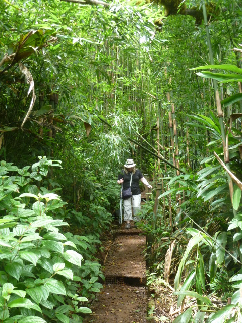
Bamboo abounds
Another path connected with ours, and it took us the couple of hundred feet up to the summit.  However, as we gained height we entered a very dense, dark and damp bamboo forest.
A boardwalk helps get through the bamboo forest.
The contrast with the aridness of the island a few miles away was startling.  Despite the heat (36C) of the coast, I preferred it to the sweltering humidity at the top of the mountain.
Land crab at 800m (2,500ft)  above sea level.
Every so often, we came across the strange land crab, which lives its life in holes on the mountainside, miles from the sea. About 3 times a year, thousands emerge from their burrows for a huge get-together on a beach.  It's thought they wait for the full moon....
Unusual sight for Falkland Islanders - tarmac roads!
As well as plant species, many animal and bird species were brought the island over the years.  Some survived well, but were later abandoned as people came and went.  Feral sheep and donkeys are quite a common sight.  But others, such as ostriches and guinea fowl, weren't quite so successful at eking an existence on extinct volcanoes.  An exception was the mynah bird, brought as a house pet from India, which  is now probably the most common land bird.
~~~~~~~~~~~~~~~~~~~~~~~~~~~~~~~~~~~~~~~~~~~~~~~~~~~~~~~~~~~~
In for the long haul....
But the animal that has been coming to Ascension Island long before men found it is... the Green Turtle.  Despite their very slow speed on land, precise numbers are difficult to estimate.  But certainly several thousand congregate offshore to mate in February and March.
Making tracks.......

 The turtles swim about 1400 miles from the Brazilian coast to mate in the shallow waters around the island.   The females may mate with several males (and each male can fertilise her eggs, so a nest of 150 eggs might have 5 or more fathers!  By the way, no males come ashore. Typical...).
In the nest.
Between March and June, the females come ashore at night to lay their eggs in deep pits.  It was easy to wander down to Long Beach in Georgetown before dawn and find the stragglers trying to finish burying their eggs in the sand, before hauling themselves back to the safety of the sea.
No shortage of fresh eggs here!
About 150 eggs are laid at a time and some females lay about 5 times!  Guided tours of the beach are held a couple of nights per week, when experts explain the lifecycle of this amazing creature.

The turtle population seems to be increasing after centuries of persecution, mainly by the Royal Navy.  Many thousands of turtles were captured and kept in seawater pools near the beach (they are still there) to provide fresh food for passing sailing ships.   Until about 1920, when the damage to the population was recognised, turtle soup was a traditional starter at special Royal Navy dinners,
The welcoming surf
 After about 2 months, the eggs hatch - all at the same time!  Buried under about 5 feet of sand, a baby turtle couldn't dig its way out of the nest.  So, the key to survival, and life, is for the all 150 hatchlings in a nest to push each other up to the surface.

"OK, lads.  The coast is clear. Run for it!"
They then emerge, or "erupt", together, and make a dash to the sea, where they can begin their lives.  Or not, if the frigate birds have their way.....
A nest erupts.  No need for long lenses.
Most "eruptions" of hatchlings occur at night, when predators are asleep, and perhaps because the moon is reflected on the sea and provides a beacon for the turtles to aim for.

Bird food.

However, we witnessed an eruption during the day, and it was easy to see why it's thought only 1 in 500 turtles make it to adulthood.  We saw one little turtle on its back, and knowing it couldn't turn itself over, I intervened to give it a chance in life....

A helping hand
If you want to know more about the turtles, this is a good site >> 
http://www.ascension-island.gov.ac/government/conservation/our-species/marine-turtles/

Here is a short video of one turtle's first steps.  I know I cried (when my boots got soaked....).......


~~~~~~~~~~~~~~~~~~~~~~~~~~~~~~~~~~~~~~~~~~~~~~~~~~~~~~~~~~
I had a funny encounter on arrival on Ascension Island - a place I'd never been before.  The hotel had a pleasant outdoor bar, and I was just about to catch the barmaid's eye to order a bottle of  "7 Giraffe" beer (from Alloa!) when an attractive young woman sitting at the bar said - "Hello, Peter!"

I was somewhat taken aback that someone in this remote spot could possibly know me, but felt sure I had met her somewhere before: just couldn't, for the life of me, remember where.  She interrupted my thoughts about early-onset senility, by reminding me that we met briefly in Stanley about 2 months earlier. Phew!

  Small world!

Her plan was to soak up the sun for a week - delaying the return to the UK's cooler climate as long as possible. I, on the other hand, wasn't that keen on the heat, and longed to be in England, now that Spring was there..........

 More anon,

Peter,
(now back in snowy Stanley having skipped from Autumn to Spring and back to Winter in a month).


Tuesday, 16 April 2013

Sunsets & Stamps

[Random observations of my life as an incomer, in the Falkland Islands.  The next post will not be for at least a month, as we are on our travels, again.  Hope this, and the older posts, will give you an insight to the Falklands].

This week the weather gave us some wonderful displays and also some horrendous and unusual conditions.  As I write, the lightning is flashing across the overcast sky, and the rain is belting down.  "The risk of sunburn is LOW", as the optimistic radio weather announcer puts it!
The Corniche?  
 I do like unpredictable weather - I don't think I could live somewhere where you know for weeks in advance what the weather will do.  Here, even if it is sunny and clear, you always take a jacket, and warm layers...
Watersports.
So, as we in the Southern Hemisphere slip into Autumn, and I slip out of the country, heading north for a change, I'll leave you with a few images and impressions of Stanley, capital of the Falkland Islands.
I've also seen a water-skier recently...  plus kite-surfers like this chap >
http://www.youtube.com/watch?v=G5FhUStwb4I
You might see the wreck of the Lady Elizabeth in the background, and some dolphins appear after 30 seconds.
Evening light
 I've been showing a newcomer around Stanley, just to help her get her bearings, and also to show that not all penguins have disappeared.
Watching the penguins in the minefield
We were lucky enough to spot dolphins, but they were too far away for my little camera to capture.
Back from a swim
 Penguins are much easier to photograph, but I will practice on the dolphins.
I know what you're thinking..."Not another @#* sunset!" .  But they're all different....
However, I doubt there will be many more good sunsets for a while.  It's now dark by 6.30pm.
Lamplight at twilight
As an alternative to watching the skies, we now receive 3 terrestrial UK TV channels, (BBC1/2, and ITV) rather than the consolidated mishmash via British Forces Broadcasting Service, so we no longer see adverts aimed at the military audience on topics like PTSD (Post-traumatic stress disorder),  and what's on at cinemas in Germany and Camp Bastion!
Very southerly Nordic Walkers heading to strange cloud (or alien spaceship)
Unfortunately, we have also lost a fair amount of Sky Sports output, (which is a concern to cricket fans in the household), and also Game of Thrones.  Still, we can always look out the window if we want an interesting scene to observe.  The weather is rarely dull!
An official invitation (and  Falkland's marine mammals stamps).
"Mr P regrets....".   Sadly, I cannot attend this reception, but maybe I'll get another chance?    I do like the stamps here...New sets come out every other month (or so it seems), and most are memorable.  Let me know if you want me to send you a postcard (with a stamp!).  It might be the closest you get to a dolphin!
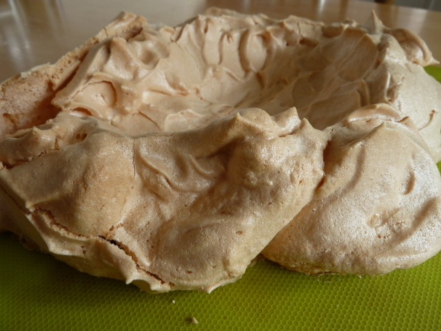
A scale model of Torres del Paine, or My First Pavlova?
One aspect of life that I've enjoyed here is having more time to experiment at baking.  While still very much a novice, I can at least try baking stuff I wouldn't even had considered 18 months ago - scones, bread, meringues, muffins, steam puddings,  and other  light options.
Not local fruit!
Last week, I cooked for some friends, and tried some South Georgia reindeer in red wine.  It was, even if I say so myself, delicious.  
 ~~~~~~~~~~~~~~~~~~~~~~~~~~~~~~~~~~~~~~~~~~~~~~~~~~~~~
Sunday saw the regular Ramblers walk.  The plan was to walk up Smoko Mountain, but heavy fog at about 200 feet, meant that idea was swiftly abandoned.  Plan B was to walk up a lovely river valley (at least, I was told it was lovely!), and hunt for the elusive Teaberries, which reportedly were ripe for picking!
Rock slabs rear out of mist
Some of the chaps felt a more energetic walk was required so wandered round in the mist, and tried, sometimes successfully, to cross a fast-flowing stream.
Male walkers eagerly awaiting the return of the berry pickers to the cave....
We agreed to rendezvous with the Teaberry pickers for lunch in a lovely viewpoint (at least, I was told it was a lovely viewpoint), but lunchtime came and went with no sign of the other group.   It was at this point that I realised I had all my partner's food and drink in my rucksack......Oh well: waste not, want not!
The elusive and delicious Teaberries.
Possibly more worrying, it soon became apparent that our macho group also had all the maps, the GPS, and most of the mobile phones!  After what seemed like an age peering into the fog, we eventually heard familiar voices floating towards us through the gloom!  An old myth about a certain gender's inability to navigate was about to be dispelled!

Quickly diverting attention from the unequal distribution of equipment and food, we eagerly asked our companions how they had got on with the berry-picking.  Hurrah! A bountiful supply had been found!
Recipes for Teaberry muffins,  Teaberry pavlova and Teaberry vodka were exchanged as we walked back to the parked cars.

An enjoyable day out, despite the fog.
~~~~~~~~~~~~~~~~~~~~~~~~~~~~~~~~~~~~~~~~~~~~~~~~~~~~~~~~~~~
End of an era?

A Public Holiday has been declared on the Falklands for Baroness Thatcher's funeral tomorrow.  The Islanders are very grateful to her decision to send a Task Force, 31 years ago.....

I hope the main London event, and the London Marathon, pass peacefully.  My thoughts are with the people of Boston.

Back in a month.

Peter


Monday, 8 April 2013

The Towers of Torres del Paine....


[Continuing a personal blog of life in the Falkland Islands, with the occasional detour to Chile. Last week, I described getting to Torres del Paine National Park in Patagonia.  This week, I try to show some of its highlights.  By the way, I see there are some readers of this blog in Ukraine and Kazakhstan.  Hello to all!]


Torres del Paine National Park is famous for its guanaco herds.
In January, my wife and I had a short visit to the Torres del Paine National Park, in Chilean Patagonia.  It's in a remote landscape, much of which is covered in a huge ice-cap, with scores of glaciers still shaping the land.
Icebergs in Lago Grey
I've always been interested in physical geography and found the park a fascinating display of the topics I learned about in school (many moons ago!) - glaciation; erosion, hanging valleys, etc.

Glaciers have gouged out deep troughs between the mountains and these were filled with countless years of melt-water.  One in particular, Lago Grey, had a huge glacier at one end, which regularly calved icebergs into the lake.
Glacier's end
You can walk to, and onto, the glacier, but we were short of time and took a 3-hour boat trip from one end of the lake to the other, and back.  The boat took about 30 passengers and we reached it by a short zodiac trip as the lake had silted where the jetty was.
The glacier has retreated about 200m in 10 years.
The area is notorious for its strong winds, and that day was typical.  Most people got some icy water down their neck, and once under way in the middle of the lake, the "cruise" resembled a desperate expedition in mid-ocean.  So passengers stayed below decks in a bid to keep themselves and their cameras dry.
Ice scouring the tilted layers of sandstone
But after about 30 minutes we approached the far end  of the lake where the mountains afforded some shelter.
Glacier or meringue nest?
It was amazing and breathtaking to see a glacier snout close-up.  We could sail right up to rock faces that, until a few years ago were covered in scouring ice.  The marks left by the ice were still embedded in the rock.
Zodiac picking up walkers.
We could also see the thousands of exposed layers in the sandstone rock, much of it twisted and contorted by huge forces.
Future iceberg
I have seen glaciers in Iceland, and Antarctica, but none as close as this, or with such an easy access.  No hiking miles across wastelands -  there was even a bar to serve hot drinks once you noticed the temperature had plummeted!
New icebergs making their way down Lago Grey
The cruise sailed for a mile across the end of the glacier, hugging the shimmering ice cliffs, before turning and heading back to base, dodging icebergs, and providing an unforgettable highlight of our trip.
~~~~~~~~~~~~~~~~~~~~~~~~~~~~~~~~~~~~

Our other main highlight was a walk up to the Torres del Paine themselves.  "Torres" is Spanish for towers, and is extremely appropriate - 3 vertical, windowless, granite skyscrapers!  (It's not clear who or what "Paine" was, but we did "feel the pain!").
View from hotel

We could just glimpse the top of the towers from our bedroom window, but quite often they were shrouded in cloud.   We had heard tales in the bar of people who had hiked uphill for several hours only to gaze at mist when they got to the viewpoint!   However, we only had one day spare to do this, so set off early one dank morning, hoping for the best.
Happy not to meet some horses.....

We followed a well-worn horsetrack up a side valley for about 3 miles, stopping frequently to enjoy the growing view, and to get our breath back.  The path was very narrow in places, and it was with some relief that we didn't meet any horses coming the other way.  There was a 500-foot drop into the river on one side!
4,000ft waterslide, and contorted landscape.

After a couple of hours we came to a Refugio - a hostel and camp-site on the banks of the river.  Here were toilets and a cafe,  and for the campers, it meant a shortened walk to the Torres.


We continued on the path, crossing the river, and enjoying the shade provided by the evergreen beech forest.
Evergreen beech forest

The path undulated higher and higher up the valley, until we came to the foot of a steep scree slope.  This is where the real uphill effort started, like climbing a set of stairs for an hour,  and where I missed my Nordic Walking poles the most.  Oh, how I missed them!   (Given the number of people using trekking poles, I assumed they were readily available to hire.  But, it seems, only in Puerto Natales, 80 miles away).
The scree slope approaches...

Gradually, with many stops to admire the view, we steadily gained height.  Our total gain was about 1,000 metres - about the same as climbing a Munro in my native Scotland.
http://en.wikipedia.org/wiki/Munro
Nearing the top of the scree.

But it was definitely worth the effort!  Thank goodness the clouds had cleared!
Raw glaciation.  Ice vs Granite
For a glaciation nerd, this was seventh heaven!

Looking across to the towers, some people said they could see climbers on them, but I couldn't make them out.  In fact, until I read a book, "Against the Wall", by the climber Simon Yates, I doubted they could be climbed at all!  They were sheer, for 2,000 feet.
http://en.wikipedia.org/wiki/Simon_Yates_(mountaineer)
We made it!
And, in fact, I later discovered that the Central Tower (at 8,100 feet; 2460m)  had first been climbed as recently as 1963, by the renowned British mountaineers, Sir Chris Bonington and Don Whillans!
A quick snap before the weather changes.
I would have loved to spend hours up there, but we could see the weather changing by the minute.  Simon Yates describes, in his account of the climb,  violent storms that threatened to blow him off the cliff, and yet were not felt at its base!
One last look before heading down.....
So, we enjoyed probably the most scenic setting to eat a packed lunch, took dozens of photos as the light changed, and then turned to negotiate the scree slope.  It was probably a good thing that the view disappeared in seconds, meaning we could concentrate on our footing.  
The sign guides you through the scree.
Once again rueing the mistake of not bringing poles, we gingerly made our way down the path, through the beech forest and back to the Refugio.  
Grey granite, topped with brown sandstone
This route is part of the famous "W" trek, so-called due to its shape.  We had just walked the right-most part of the "W" .  The whole circuit takes about a week, so, sadly we could not do it all in the time available.  It's not actually a circuit, as some of you will know, but the boats and ferries that ply the lakes connect hikers to the next section, or to lodging for the night. 
Excellent signs don't hide the truth.  It is uphill!  Torres in distance.
A last glance back at the tops, and then we continued for about an hour back to civilisation and our hotel and a hot soak  - very tired; very happy.  I feel for those who got all the way up there, only to see cloud.
Friendly sparrow at the Refugio.
But, perhaps it's better leaving something unfinished, as an incentive to go back?

If anyone would like more details on the Torres del Paine National Park, check this site, or ask away.  I'll try to help if I can.  There are also good online travel forums such as Lonely Planet and TripAdvisor.

I wonder where we'll end up next...?

Peter