Last month saw a group of walkers set out to climb Mt Usborne - at 2310 feet (705m.), the highest point in the Falkland Islands .........
 |
| Mt Usborne from Darwin. |
The mountain is named after the Ship's Assistant on the
Beagle, which brought Charles Darwin to the Falklands in 1833. You can get good views of it from the settlement of Darwin, which is about 70 miles south-west of Stanley, the capital.
 |
| In convoy across Camp |
On a breezy Sunday morning, about 10 of us set off for the 60-mile drive west from Stanley, and
then a 5-mile off-road track to the base of the mountain. This track
gets rough in places, but we had a couple of experienced drivers in
the convoy, who could pick their way through the traps.
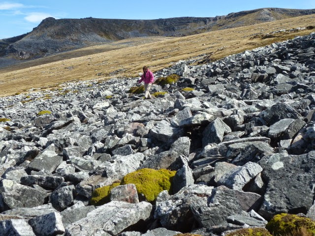
 |
| Negotiating a small stone run |
The group parked the cars around 11am,
and set off under grey and blustery skies. Luckily, the strong wind
was at our backs as we clambered up the steep slope. We crossed a
few stone runs, but eventually reached the summit plateau after about
90 minutes.
 |
| The summit cairn. An old exhaust? |
 |
| Blowing a hoolie at the top! |
Unfortunately, the wind had increased in strength, and standing on the exposed plateau was an effort. After a few photos and signing the visitor's book, we headed east to find a more sheltered spot. Rather surprisingly, the north face of the hill was very much steeper than the south, and had 4 corries, each with a tarn. I was familiar with these geographical features from visiting the Scottish Highlands and the Lake District in England, but their presence indicated glaciation had occurred here, at some point in the distant past.
 |
| A sheltered spot...yes, that's snow! |
However, I don't think there is any other evidence that the Falklands were once glaciated, so it was a surprise to see these features at all. We soon found a broad ledge below the ridge out of the wind, and we had an enjoyable picnic looking down 1,000 feet into a corrie containing a few snow patches.
After the refreshments, we continued about another mile east along the ridge, and then dropped down about 800 feet into a corrie. One of our group wanted to dip his fingers (it was too cold for toes), into each tarn, and so we continued west, sheltered from the gale under the long ridge.
 |
| On the summit ridge. |
 |
| More snow! |
 |
| The most easterly tarn |
Tarn comes from Old Norse. This article describes how they are formed. The tarn above was sitting in an almost-perfect bowl, formed by ice.
http://en.wikipedia.org/wiki/Tarn_%28lake%29
 |
| Looking back west along the summit |
 |
| Tarn from the east |
 |
| View from the north, looking southwest. |
 |
| Another tarn with lots of packed snow. |
 |
| Heading for the Black Tarn |
 |
| Black Tarn |
After a few hours of checking out the corries and touching the tarns, we came to a stunning view, overlooking the famous Black Tarn. The only problem was there was no obvious route down to it! After a few dead ends, we clambered down a steep stone run, sometimes using hands and bottoms to negotiate a route through these huge boulder fields.
 |
| Steep stone run |
This article gives more information about how stone runs are formed >>
http://en.wikipedia.org/wiki/Stone_run
 |
| Very steep stone run... |
Charles Darwin, when he saw them during his visit of 1833, en route to the Galapagos and his Theory of Evolution, called them "rivers of stone". Although my native Scotland now has a similar climate to the Falklands, it was completed glaciated during the last Ice Age, so this geological formation never existed in my homeland.
 |
| Black Tarn, looking south to Mt Usborne |
The views were worth it! They reminded me of some dramatic scenery in the north-west of Scotland. Well worth exploring if you can't get to the Falklands!
 |
| Transport awaits. One last stone run to cross. |
Climbing out of the bowl, we realised we now had no protection from the gale, and it was going to be a long, tiring slog back to the cars. Despite being marginally downhill, we still had several more stone runs to cross, and a steep hillside to walk round. I was very glad of my Nordic Walking poles which kept me upright most of the time.
 |
| Returning to the road |
Arriving back at the cars about 6 hours after setting off, we could check GPS and pedometers as we waited for the stragglers. I had walked for 5 hours (sat down for 1 hour), and covered 10 miles (16 kilometres). My pedometer said I had taken 22,992 steps, and who was I to argue? It felt like it!
 |
| Follow that car! |
Friends kindly transported me back to
Stanley, where a hot bath and cold beer were all I was thinking
about......
Another Grand Day Out! Thanks to all who made it possible.
Peter

Hoping to do this on Sunday. Any advice for a starting point. GPS of the track or start point.. Thank you and great pictures by the way..
ReplyDeleteThe track from the road should lead to the saddle. Park,walk to the saddle, then turn right up the slope. Don't do what I did on my second visit and try to make a beeline across stone runs. Avoid them. Do take sensible precautions, like not going alone, letting someone know your plans, and taking gear to keep warm, navigation and communication.
ReplyDeleteTo be clear, its possible to drive to the saddle, or even to the summit, depending on car and driver .
ReplyDeleteThank you very much. I take it that the track is from the Darwin to Port Sussex road after the 2 river crossings.
DeleteIt's on that road, yes, but I can't be precise from this distance. I do have the the co-ordinates on my GPS, but it is still in a box somewhere.... By the way, you also need the landowner's permission to be on their land, in case you, or others, weren't aware.
Delete