Hi,
If you've stumbled across this blog while searching the Internet for photos of rusty steam trains, this is your lucky day! [I'm jotting down my experiences whilst living on the Falkland Islands with my wife, and this is a continuation of our report of a trip to Bolivia and Chile. (The previous instalment is here -
http://peterspenguinpost.blogspot.co.uk/2012/08/tell-me-mr-bond-what-do-you-know-about.html ).]
But there is a lot more to Bolivia than some old trains.......
 |
| The end of the line.... |
These locomotives are in an abandoned "train cemetery" on the edge of Uyuni, in south-west Bolivia. It had once been an important junction for passenger and freight trains - exporting valuable tin and silver via Chile and Argentina. (My school Latin lessons are coming in handy - "argent" is silver in several languages. The River Plate or Rio Plata, is from the Spanish for silver!).
 |
| Run into the desert |
The railways were vital to the economy of the country, but tin is less valuable these days, and oil and gas are now the mainstays of this landlocked country. The tin was often in the hands of a few "tin barons", a fantastically wealthy elite, who employed thousands in their mines, sometimes without pay! They could control governments and did very little to drag Bolivia out of the agrarian backwater it had been when the Spanish conquistadores arrived around 1540. The trains were to get the tin to the market, across deserts and mountain ranges, not to transform the country.
 |
| In need of some repair. |
In nearby Pulacayo, there had been a massive silver mine, employing about 20,000 miners at its height. We were told that the owner had also been the President of Bolivia in the 1920s, and only provided food and lodgings to the miners and their families - no wages! The mine is worked out, and only a few miners remain, showing tourists around.
 |
| Butch Cassidy was here! |
Some of the earliest trains to arrive in Bolivia remain here, including one robbed by the legendary Butch Cassidy and the Sundance Kid. One of the carriages has bullet holes in it from their attack!
 |
| One of the earliest locos. |
From Uyuni and Pulacayo, we continued east, through mountains and valleys that corrugate between the high Altiplano in the west and the sub-tropical lowlands of the east. I'm not sure if corrugate is a verb, but it was as if the land had been scrunched up by some giant force, into thousands of undulations - about 3000 feet in height. We saw a couple of cyclists, but these seemed dispiriting roads for cyclists.Up for 5 miles, down for 5; up for 8 miles, down for 6, and so on.
 |
| Brown = Altiplano, Lt Green = lowlands, Dk green = central mountains. White = Salar de Uyuni, Blue = L Titicaca or Pacific. |
Potosi is marked on the above map. We had just crossed the huge salt flats, marked white.
 |
| Potosi - once the world's largest city |
After a few hours, we came to the city of Potosi at 13,240 feet (4090m), the biggest in the world in the 1600s.. It sat on the slopes of the Cerro Rico (Rich Hill) mountain, from which vast quantities of silver were extracted, destined mainly for the Spanish monarchy. From about 1546, thousands of indigenous Indians were sent to Potosi as a tribute to the Spanish conquerors. When the miner inevitably died or broke down, (usually after a few months) another family member had to be sent. Eventually, the local supply of labour dried up, and thousand of slaves were imported from Africa.
http://en.wikipedia.org/wiki/Potos%C3%AD
 |
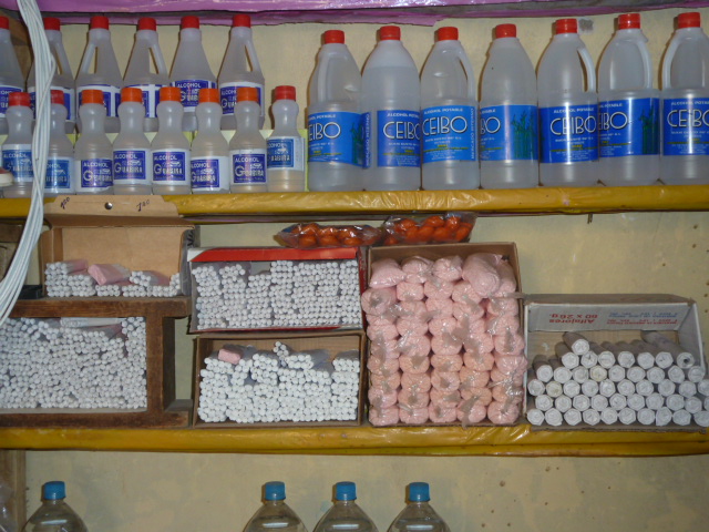
| Shop for miners - alcohol, detonators, matches, dynamite..... |
It's reckoned a third of all silver in Europe came from here, but eventually the silver ran out and the Spanish monarchy ran up huge debts fighting wars. Even with all that "free" silver, they owed millions to German bankers. Just as well lesson were learned, and history didn't repeat itself!
 |
| One of the many mine entrances. The discolouration is not from smoke! |
We took a guided tour of the
outside of the mine - not brave enough to venture underground with our gifts of dynamite and strong alcohol to appease the spirits that protect the miners. Catholicism may have arrived with the Spaniards, but most Bolivians stick to the ancient beliefs. Near the mine entrance above, we noticed a strange smell and the blackened rocks. Apparently, this was where llamas were ritually sacrificed, and their blood smeared over the entrance, to help ensure the safety of the workers.
 |
| Cathedral of St James |
Elsewhere in the city, a few streets had architecture that would not be out of place in Andalusia. And the churches were reminiscent of European buildings, except in a few details, like the rare carving of a local Indian, with her broad skirts.
 |
| Carving of local Indian |
But we found hilly Potosi a struggle to walk round, so were happy to continue the journey to the much lower and more comfortable capital of Bolivia, Sucre.
 |
| Sucre |
Sucre is a World Heritage Site, and the buildings in the centre are all whitewashed, again giving a very Andalucian feel. And being at "only" 9,000 feet above sea level (2750m), it was relatively easy to wander around the streets and squares. The market, especially, was a sight for sore eyes, or for people who haven't seen large number of vegetables for a few months!
 |
| Sucre fruit & veg market: slightly better choice than we were used to in Stanley! |
 |
| Stallholder and fruit and baskets, Sucre |
As I may have mentioned, Bolivia has hundreds of different types of potatoes - some for roasting, others for mashing, pureeing, baking, making chips, etc etc. Many of these were for sale in their own section of the market. In Stanley, we have recently seen 2 types of potato in the shops - big or small!
 |
| Some of the 500 potato varieties in Bolivia |
There was also a large fruit section, with alleyways of nothing but banana stalls. A far cry from our early experience in the Falklands when bananas were as plentiful as hens teeth....
 |
| Banana stall, in the banana section of Sucre market |
So, it was a joy to see the beautiful and plentiful abundances in Bolivia. Several people had told us that no-one need go hungry here, as the food is so cheap. Certainly we always seemed to get lots of change when we bought bananas!
 |
| Fruit, fruit, fruit......mostly unknown to me! |
The stylish streets were full of restaurants and bars, as the residents and visitors brought a cosmopolitan air to the city. One of the earliest universities in South America was founded here in 1624, and there are many language schools in the town.
 |
| Whitewashed streets, Sucre |
The Supreme Court and many lesser courts are also in Sucre, and the streets around the court area are filled with legal offices, open to the street. Sometimes lawyers sit on the pavement with a typewriter on a desk, drawing up letters for clients.
 |
| "St Rita - LAWYER for impossible cases"!? |
Sucre had been the capital of Bolivia (or Alto Peru, as it was known at independence in 1825), but had lost out to La Paz for most of the governmental functions in 1898, as the dwindling output from the silver mine at Potosi meant the region was no longer the powerhouse of the country.
And so, it retained its colonial architecture, and elegant buildings and plazas, without obtrusive industries or unsightly squalor that can be a feature elsewhere.
 |
| Clock Tower, Sucre |
And, apart from 2 blots on the landscape, (both, apparently, built by the same man who built our unsightly modern hotel in Potosi), the city retains its charm and a feeling of affluence unusual for Bolivia.
 |
| Sucre square |
At night, the well-lit streets are full of strolling residents and visitors. The restaurants were plentiful and reasonably-priced, most with a good range of very drinkable Bolivian wine. It was as good as most other wines I've tasted, but I don't think they produce enough to compete in the export market against neighbouring Chile and Argentina.
 |
| Tour operator. |
All too soon, we had to move on from seductive Sucre for the delights of La Paz, another 4,000 feet higher. En route to the seat of government, we made a scheduled stop at the city of Cochabamba - a major agricultural centre. On landing, we had to leave the plane, walk across the tarmac to the terminal, walk the length of the terminal and out another door back on to the apron again.
 |
| Presidential Guard of Honour relaxing |
Outside the terminal were hundreds of soldiers and a huge band in ceremonial dress. Looking like extras from a film of my youth - "The Alamo" - they were in fact a guard of honour for Argentina's President Christina de Kirchner, who had just concluded a deal with Bolivia's President Evo Morales about buying some of Bolivia's surplus oil and gas.....
 |
| Illyama, overlooking La Paz. |
President Morales is a hero to many Bolivians. The first President in Latin America of native Aymaran origin (rather than of European descent), he has implemented many changes to benefit the indigenous peoples - we saw new schools in almost every remote village we passed. He is very much a man of the people, and has revived ancient cultural events. After being sworn in as President, he attended an indigenous spiritual ceremony at the ancient complex of Tiwanaku, and was created Supreme Leader of the Aymara people. Possibly a bit like David Cameron being anointed by a Druid at Stonehenge.
 |
| Presidetial palace, La Paz. |
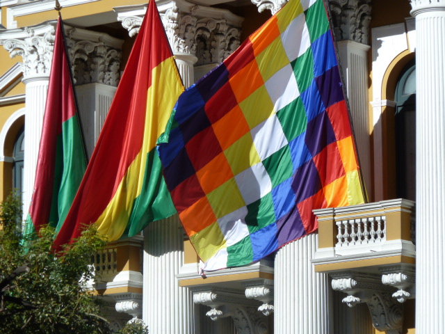
Bolivia has a Diversity flag of 35 differently-coloured squares, each colour representing a different ethnic minority. And, compared to neighbouring countries where the indigenous populations were either virtually wiped out or suppressed, it is obvious to any visitors that the pre-Spanish cultures are alive and thriving in Bolivia.
 |
| Local resident with ubiquitous mobile phone and bowler |
However, exploring La Paz was not that comfortable, given the altitude and steep gradient on every street! Added to that was the choked and choking traffic, comprising mainly of minibuses, and large, ancient 50-seaters, which seemed to have been donated by other countries, decades ago, as they updated their own transport options. The city also sits in a valley, and the air is trapped by the high Andean peaks all around. To escape the smog, we headed UP another 800 feet to Lake Titicaca, and the amazing site of Tiwanaku.
http://en.wikipedia.org/wiki/Tiwanaku
 |
| Carved heads in temple wall |
Tiwanaku is a temple complex, and also the name of a people who inhabited the region before the Incas. (Some people think the Incas took over Tiwanaku towns and buildings and claimed them as their own, and when the Spaniards arrived, the Incas got all the credit. I couldn't possibly comment......)
 |
| Solid stone (one piece) steps |
The buildings that have been excavated in the last 50 years or so, show an incredible skill at handling and dressing massive stone blocks. And unlike Inca buildings, these were held together by metal ties for solidity. The walls are perfectly aligned and smooth and square for hundreds of metres. Gateways are carved out of huge solid blocks of stone, which would cause problems to move today, never mind in a society without the wheel, or draught animals.
 |
| Giant figure with 2 left hands |
There is so much of interest at Tiwanaku and about their culture, that I can only touch on it here. One aspect that is still impressive is the output from the specially-designed fields. These were raised and surrounded by water-filled ditches, which created a micro-climate in the arid region, so much so that a population of 100,000 was being fed at the peak of the city's power. However, a long, 30-year drought around 1,000 years ago saw the water levels of Lake Titicaca drop and the shores recede from the city, by about 20 miles.
 |
| Bolivian, Diversity and La Paz flags. |
Without food to feed its people, the society broke up and dispersed to more fertile areas to the south and west. Around 1460, the Inca empire expanded into what is now Bolivia, and utilised many of the buildings as Sun Temples, only to find Europeans arriving, looking for gold, a few decades after them.
 |
| Open-air model village, L Titicaca |
One of the few aspects of culture that continues unchanged is the traditional reed boats on Lake Titicaca. Some of you may remember the Norwegian explorer, Thor Heyerdahl, attempting to show that cultures from South America and Egypt may have been connected, or at least, communicated ideas with each other, such is the advanced architecture and astronomy that is found in both regions. With the Ra 2 expedition, he demonstrated that it was possible to cross the Atlantic in reed boats, and actually did this in one built by a Bolivian, who is still building these boats today.
http://en.wikipedia.org/wiki/Thor_Heyerdahl
 |
| Dawn over the Andes from Sun Island |
Using a slightly more modern hydrofoil, we continued on to Sun Island, which was a traffic-free haven in the lake. Mules helped carry bags and water and beer up the steep slopes to simple hostels with stunning views - east to the Andes and the rising sun, and west towards Peru and the setting sun. Easy to see why it was a sacred spot for more than one civilisation.
 |
| Reed boat |
The island is crossed by good paths, part of the network of roads built by the Incas to allow easy access to the outposts of their empire from their capital in Cuzco. But this good network also assisted their speedy downfall, allowing the Spaniards to travel quickly throughout the empire on horses, which the Incas had never seen. And by taking hostage and killing the Inca king, Atahualpa, the conquistadores imposed their will on a subjugated people.
 |
| Cordillera Real from Moon Island |
So, it is all the more remarkable, that only in the last decade have the indigenous people re-asserted themselves and elected one of their own in Bolivia.
 |
Across the Andes by frog plane |
Travelling back across the Altiplano plateau and through the huge shanty town of El Alto, which surrounds La Paz airport, we could only marvel about the peoples who had lived for thousands of years at an altitude that our puny lungs could barely cope with. During a very long take-off through the thin air, we had time to glance
down to La Paz in the valley, and over to the high Andes, as we crossed them into Chile, or, as Bolivians would say," Bolivia!". Bolivia lost its coastal region to Chile in the War of the Pacific in 1898, including the worlds largest copper mine. It still rankles.
 |
| Gardens in Vina del Mar, near Valparaiso |
Central Chile was another contrast, with verdant vineyards, and balmy coastal resorts. Santiago could have been in a Mediterranean country - good transport; great food and wine; ski-ing, and swimming in the ocean within 2 hours....
 |
| Easter Island resident |
I might say more about Chile another time. We intend to go back, if we can. But we might not manage to return to Bolivia - one place that won't ever be confused with somewhere in Europe.
 |
| Santiago Cathedral. |
Hasta la Vista
Peter