Continuing the tales from the South Atlantic. October brought gales, fog, snow, penguins, memorable dinners, stunning walking, the return of the tourists, and much more.....!
 |
| White Horses, Long Island Farm (courtesy of wife, and landowners) |
Spring has arrived in the South Atlantic. Lambs are being born, birds are laying eggs, the days are getting longer, penguins, seals and albatrosses are returning to breed, and the weather is gradually improving.
 |
| Black-capped night herons nesting |
October - the April of the southern hemisphere - sees winter finally relinquish its grip on the weather, with just a few snow flurries to remind us we are only 600 miles from Antarctica.
 |
| HMS Iron Duke visits Stanley |
However, the Falklands are the same distance from the Equator as London, so despite the slightly cooler weather, the islands receive plenty of daylight in Summer. This, and their remoteness, makes them ideal breeding grounds for sea-going birds and mammals of the southern ocean.
 |
| One of the first Magellanic penguins to return to their burrow and await their partner. |
Every Spring, thousands of birds, seals, etc return to the place of their birth to continue the cycle.
 |
| Outdoor exhibit at the new Museum. |
On the human side of life, a new museum has opened its doors just in time for the tourist season. It covers the Natural History of the Falklands, as well as the social history of the people here.
 |
| You don't want to get this close to a live Leopard Seal! Note the 3-pronged teeth! |
There are excellent exhibits of Victorian-era shops and homes; coverage of the 1982 conflict; modern life, including the Fishing and Oil industries. There is a room set aside for Antarctic exploration, much of which used the Falklands as a supply point. A hut, which was used by British explorers in the 1950s, has been transported to the Museum, and offers a great insight how men survived that harsh climate for months on end.
 |
| Ramblers on the ridge. |
Just as a Postscript to the Museum, a couple of recent tourists made some very blunt comments in the Visitors Book, suggesting that the Falklands belonged to Argentina. There was also some anti-British graffiti left around Stanley at the same time, and in the same handwriting! As these visitors had signed their names, it was quite easy to check their Facebook pages, and see them boasting of their exploits there...
 |
| Energy-sapping whitegrass |
Meanwhile, the Ramblers group organised a very long and scenic walk in the hills to the west of Stanley. Unlike most of the hills a few miles to the south, these slopes did not see any fighting or mine-laying, but they had panoramic views that made the effort of ascending them worthwhile.
 |
| Mt Vernet summit |
On a very cold Sunday, a group of us set out from near Estancia Farm, while another group took some cars to the end of the walk at Long Island Farm, where we would all meet up 4 hours later.
 |
| Watching for stragglers |
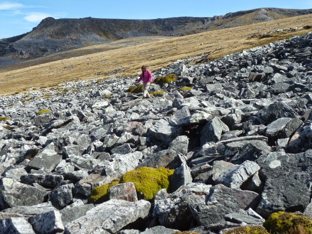
We estimated the walk was about 12kms (8 miles), which may not sound massive, but the ground underfoot had no paths, and was either ankle-twisting swards of white grass, or very tiring boulder fields, known as Stone Runs or "Rivers of Stone", as Charles Darwin described them when visiting on the Beagle's voyage, which would later make him famous.
 |
| Stone runs are unique obstacles. |
These Stone Rivers are formed by repetitive freezing and thawing over millennia, and are not found anywhere else, I believe. The one we crossed is also the longest, and known as Princes Street, after the long, broad thoroughfare in Edinburgh. By coincidence, I was to fly over Princes Street a few weeks later. More of that flight soon.... A lovely, if tiring, walk!
 |
| Princes Street (grey) from the air. |
Also in October, saw the rescue of several oiled King Penguins. These were being looked after by Falklands Conservation near where we live in Stanley, and volunteers were sought to help with the feeding of the birds. After a few weeks, the birds are released back into the sea, and hopefully swim back to the beaches before the tourists arrive in numbers!
 |
| Feeding time for oiled King Penguins |
I mentioned at the start that there were some memorable dinners in October. On Trafalgar Day (October 21), I had the privilege of dining with the Commanding Officer, British Forces, South Atlantic Islands. He is in charge of all the troops based in the Falklands in order to defend the islands. A fascinating evening, but sadly, no photos.
Like London buses, a second unusual dinner invitation came along that week. This time as guest of His Excellency, The Governor, who hosted a dinner at Government House. We had a short tour of the historic building, with its conservatory housing the most southerly grapevine in the world!
 |
| Signing the underside of the table is a popular tradition... |
But, for some guests, the highlight of the tour was the snooker table on which explorer Sir Ernest Shackleton played whilst trying to organise a rescue for his men stranded on Elephant Island. A few enthusiastic people felt the need to examine the underside of the table where thousands of visitors, including the Duke of Edinburgh, Prince Andrew and many others, had left their messages for posterity.
A memorable evening in a memorable week!
Peter